A summary of global disasters occurring between 8 November 2006 - 5 March 2007. By Prof Bill McGuire of Benfield - UCL Hazard Research Centre
Storms and floods dominated the period from the end of July to early November 2006, with super-typhoon Durian devastating the Philippines and later battering Vietnam. Total loss of life due to Durian was over 800, with economic losses estimated at around US$556 million. Europe also took a pounding from winter storm Kyrill, the most powerful to strike the region for several years. It caused 47 fatalities and generated insured losses estimated at somewhere between €3 and €8 billion.
In Australia, Cyclone George made landfall on the sparsely inhabited northwest coast, taking two lives. During January, heavy falls of rain of tropical origin eased some short to medium term rainfall deficiencies, but much of Queensland, NSW, Victoria and northern Tasmania remain affected by drought.
Winter storms held much of the United States in their grip in January 2007. Three successive ice storms affected states from Arizona in the southwest to New England and the Canadian Maritimes. At around the same time, a cold wave plunged southwards across Washington state and Oregon, and into California, bringing snow to Malibu and destroying most of the citrus fruit crop at an estimated cost of US$800 million to
$1 billion. Another cold wave, this time across Bangladesh, took over 130 lives.
The end of winter in the United States brought a tornados across the southern states that took 20 lives, including eight at a school in Alabama.
Torrential rains brought flooding on a biblical scale to the Horn of Africa, Kenya and Mozambique, affecting millions and bringing the prospect of food shortages to come. Serious floods, sometimes accompanied by mudslides, were also reported from Angola, Bolivia, North Korea, DR Congo, Indonesia, Madagascar, Malawi, Peru, Rwanda, Zambia and Zimbabwe.
Geologically, the past four months have been very quiet. Volcanic activity continued at a minimal level, while significant earthquakes were confined to a Richter Magnitude 5.5 event in Kyrgyzstan, which caused damage but no loss of life, and two events in Indonesia. On 16 December, 2006, a Magnitude 5.5 - 6 quake caused four fatalities, while a Magnitude 6.3 event in West Sumatra, on 6 March 2007, took over 50 lives.
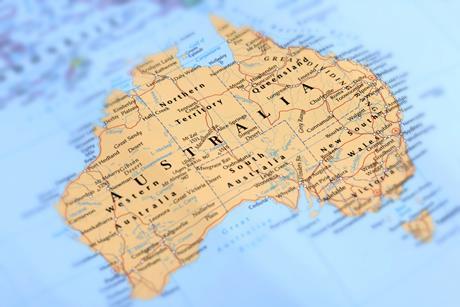
Territory: Australia
Region: Southern New South Wales (NSW), Victoria, northern and eastern Tasmania, southeastern South Australia (SA) and a coastal strip in Western Australia (WA)
Date: January 2006-January 2007
Event: Drought
Impact: The extended drought has hit agricultural sectors hard. Winter crop production in Australia in 2006-07 is estimated to have fallen by around 61% to 15.7 million tonnes, making it the smallest winter grains crop since 1994-95. The total summer crop area is estimated to have declined by around 53% in 2006-07, to 743,000 hectares. Dairy farmers have suffered not just from scarce water but much higher feed prices. Australia is the world’s second largest grain exporter and the reduced harvest has pushed up prices substantially.
Summary: For the 13 month period from January 2006 to January 2007, serious to severe rainfall deficiencies affected a large part of southeast Queensland, much of the southern half of NSW, Victoria, northern and eastern Tasmania, southeastern SA and a coastal strip in WA from Carnarvon to Albany. The situation eased in central and parts of eastern and southern Australia in January thanks to heavy tropical rainfalls but drought conditions remain in much of Queensland, NSW, Victoria and northern Tasmania. These deficiencies have occurred against a background of rainfall deficits over several years that have severely stressed water supplies in the east and southwest, and 2006 was the driest year on record going back to 1900, across parts of the south, most notably in northern and parts of eastern Tasmania, northeast Victoria and adjacent parts of southern NSW and the Australian Capital Territory. The drought exacerbated bush fires that broke out in December in Victoria and southern NSW.
Data sources:
Government of Australia Bureau of Meteorology
www.bom.gov.au
Australian Bureau of Agriculture & Resource Economics
www.abareconomics.com
Territory: Philippines, Vietnam
Region: Luzon (Philippines), Ben Tre province (Vietnam)
Date: 24 November - 5 December 2006
Event: Typhoon Durian
Impact: In Vietnam, Durian took an estimated 73 lives, destroyed 35,000 homes and damaged a further 181,000. Over 700 schools sustained some damage and over 800 boats were sunk. The worst destruction, however, was reserved for the Philippines, where strong winds, floods and landslides totally destroyed 212,000 homes and damaged a further third of a million. In total, 3.2 million people in 160 municipalities and 13 cities were affected. The death toll is estimated at around 750, mostly in the vicinity of the Mayon volcano in Albay Province, 350 km SW of Manila, where torrential rains associated with Durian mixed with ash and unconsolidated debris from recent activity to trigger major mudslides. Several villages were completely buried, resulting in a death toll estimated at between 500 and 1,000. In Vietnam, losses are estimated at $456 million, while the figure for the Philippines, including infrastructure and agriculture, is around $100 million.
Summary: Typhoon Durian began life on 24 November, as a tropical disturbance in the southwestern Pacific close to Chuuk (Micronesia). High sea surface temperatures led to Durian reaching tropical storm status two days later, and the storm continued to strengthen as it moved slowly westwards towards the Philippines. The storm was designated a typhoon on the 28th, and by the following day, sustained wind speeds reached 230kph, comparable to a Category 4 hurricane. Durian struck the Philippines as a super-typhoon on the morning of 30 November, passing first over southern Catanduanes and then across Albay province and the Bondoc Peninsula and out into the South China Sea. After being downgraded, Durian skirted the east coast of Vietnam before making landfall in Ben Tre province on 5 December and weakening rapidly thereafter as it headed across southern Thailand and into the Bay of Bengal.
Data sources: ReliefWeb
www.reliefweb.int
BBC News
http://news.bbc.co.uk
Additional sources
European Space Agency
http://earth.esa.int
Territory: United States
Region: California, Oregon and Washington
Date: 13 - 18 January 2007
Event: Cold wave
Impact: The freezing conditions had a major impact on the Californian citrus crop, particularly in the San Joaquin valley, which is the largest citrus growing region in the country. Crops of strawberries, avocados, and cut flowers were all badly affected, but lemon and orange trees were worst affected, leading to an estimated 75% of the country’s citrus crop being destroyed, and mass redundancies in the industry. Wholesale citrus prices tripled overnight, while prices to the consumer doubled or more. The loss of several million gallons of juice is expected to raise prices by a similar amount. Gross losses are estimated at between $800 million and $1 billion, resulting in Governor Arnold Schwarzenegger requesting federal disaster aid.
Summary: Simultaneously with ice storms and blizzards affecting most the rest of the country, an exceptional cold wave struck the western states. Unusually mild weather in the region was rapidly displaced on 13 January as an Arctic low pressure system brought freezing conditions and snow across Washington State and Oregon and into California. Record snowfall was recorded in Oregon and Washington, with temperatures in Seattle falling to more than -8ÞC on the 14th. On the same day in California, records were smashed as temperatures in downtown Los Angeles and San Diego fell to 2ÞC, in Los Banos (Merced County) to -6ÞC, and in the high desert city of Lancaster, to -16ÞC. On the 17th, snow fell in Malibu and west Los Angeles.
Data sources: Produce News
www.producenews.com
The Ledger
www.theledger.com
Additional sources:
International Herald Tribune
www.iht.com
Territory: United States, Canada
Region: Central, southwestern, mid-west, southern and northeastern states of the contiguous United States, Great Lakes, Ontario, Canadian Maritimes
Date: 11 - 24 January 2007
Event: Ice storm/blizzard
Impact: Close to a million householders were affected by power cuts. States of emergency were declared in Missouri and Oklahoma, and the latter was later declared a federal disaster area. Interstate highways were closed in a number of states, Amtrak rail services were affected and flights cancelled. From Texas to Illinois, around 5cm of ice accumulated as a result of three storms, leading to countless traffic accidents, which took the majority of the 85 lives claimed by the freeze across 12 US states and three Canadian provinces, including 26 in Oklahoma. Disruption and accidents in eastern states were largely attributed to blizzard conditions and heavy snowfall rather than ice. Estimates of total losses, either economic or insured, are not yet available.
Summary: On 11 January, the first of three cyclonic ice storms took hold of much of the United States. The first developed in the southwest of the country, sucking down freezing Arctic air over the warm, moist air of the Gulf of Mexico, and leading to freezing precipitation (mostly rain, with some snow) from northern Texas to the Canadian Martimes, affecting Arkansas, Illinois, Kansas, Missouri, Oklahoma, Michigan, Indiana, the New England states, the Great Lakes region, Ontario and the Canadian Maritimes. A second storm developed close to the US-Mexico border on 16 January, and tracked across southern Texas, into the Carolinas and up into eastern Canada and Maine, while a third, headed from Arizona into the Great Lakes and crossed the Mid-Atlantic States before heading north into eastern Canada on the 24th. Ice layers up to 10cm thick were reported from Missouri and Oklahoma, with 81cm of snow falling in eastern Canada. The storms were succeeded by a period of intense cold across much of the continent, with Mount Washington (New Hampshire) recording a record wind chill of - 65Þ C on 17 January.
Data sources: CNN
www.cnn.com
Science Daily
www.sciencedaily.com
Additional sources:
Rural Missouri
www.ruralmissouri.org
Territory: Europe
Region: United Kingdom, Germany, the Netherlands, France, Belgium, central and eastern European states, Baltic states, Ukraine, Russia
Date: 17 - 19 January 2007
Event: Winter storm
Impact: Kyrill was the most severe storm to affect Europe for several years, causing more damage than Jeanette in 2002, although wind speeds were less than those of the 1999 storms, Lothar, Anatol and Martin. In the UK, Kyrill was the most damaging storm since Daria in 1990. In total, the storm took at least 47 lives, led to more than 2 million homes losing power, disrupted transport and caused major damage to buildings and forests. The accompanying torrential rain led to major flood alerts in Poland, while the Dutch regions of Delfzijl and Harlingen were threatened with tides 4.5m above normal, and wholesale evacuation was narrowly avoided. In the English Channel, the container ship Napoli, shed its cargo, leading to pollution of nearby beaches and scavenging of washed-up containers by the local population. Motorways were closed in the United Kingdom and Germany. Air and rail links were disrupted, in Germany partly as a consequence of serious damage to Berlin’s Central Railway Station. Insured loss estimates range from 3 - 5 billion euros (Swiss Re; RMS) to 3.25 - 6.5 billion euros (EQECAT) and 4 - 8 billion euros (AIR). German losses have been estimated at around 1 billion euros, with the Association of British Insurers (ABI) estimating UK losses at 520 million euros.
Summary: Severe winter storm Kyrill had a particularly broad footprint and is estimated as a once in a decade event. It began life over Newfoundland on 15 January and strengthened as it crossed the North Atlantic over the next two days. After deepening to the west of Ireland, Kyrill reached the UK in the late hours of 17 January, bringing destructive wind speeds gusting to 160 kmh. After briefly weakening, the storm re-intensified the following day as it crossed the Netherlands and Denmark and headed into northern Germany, first battering the states of Lower Saxony, Bremen, Hamburg, Schleswig-Holstein and North Rhineland -Westphalia, before affecting the entire country by nightfall. Wind speeds measured in Germany reached 202 kph and the storm spawned several tornadoes before heading east into the Baltic and eastern Europe. Wind speeds in Poland reached 212kph, and in the Czech Republic topped 200kph. The strongest gust, of 225kph, was measured on the Aletsch Glacier in Switzerland.
Data sources: Swiss Re
www.swissre.com
Munich Re.
www.munichre.com
Additional sources: Insurance Journal. www.insurancejournal.com
Territory: United States
Region: Missouri, Illinois, Alabama, Georgia, Florida, Carolinas
Date: 28 February - 2 March 2007
Event: Tornado outbreak
Impact: Damage reports remain preliminary at time of writing, although the death toll is fixed at 20. Most fatalities occurred in mobile homes in Alabama, Georgia and Missouri, or at a high school in Enterprise, Alabama where a direct hit from an F3 tornado (wind speeds between 251 and 330 kmh) killed eight students and injured more than 50 others. Close to 400 homes were also damaged in the area. Another major tornado, more than 1.6km wide struck the city of Americus, Georgia, taking two lives, destroying or damaging hundreds of homes, and battering a hospital to such an extent that it had to be evacuated. Loss estimates are not yet available.
Summary: The tornado outbreak was triggered by a deep low pressure system over the mid-west that sucked up warm, moist air from the Gulf of Mexico. To the north, conditions were freezing, while to the south, temperatures were in excess of 21ÞC. The first tornadoes were spawned across Kansas during the night of 28 February, spreading into Missouri, and then on 1 and 2 March, into Alabama and Georgia. Others were reported from the Carolinas, Illinois, Florida, Mississippi and Kentucky. In total, at time of writing, more than 62 tornadoes had been reported, of which 35 were confirmed.
Data sources:
February-March 2007 Tornado Outbreak, Wikipedia
http://en.wikipedia.org
Additional sources
BBC News
news.bbc.co.uk